🗂️ Workflow & Library
How to organize and keyword your landscape photos by location
Three years and forty thousand frames from now, you'll want to find that one shot — the ridge with the good foreground rock, the bend in the river where the mist sat. Camera metadata won't help: it records the aperture and the date, but not *where the good spot was*. For a landscape photographer, location is the single most useful thing to catalogue and the one your gear captures least well. Here's a keywording scheme built around it — one that starts in the field, not as a rainy-day chore six months late.
Every guide to photo organisation tells you to keyword — tag your files with searchable terms so you can find them later — and most of that advice is about your RAW catalogue software: folder structures, controlled vocabularies, ratings. All useful. But it usually misses the keyword a landscape photographer actually searches by years later: not “sunset” or “long exposure,” but where. You rarely think “show me my f/11 shots”; you think “where was that gorge with the turquoise water?” That’s a location query, and it’s the one piece of metadata your camera records worst. Here’s how to organise around it.
Why location is the keyword you’ll actually search by
Your camera stamps every frame with a wealth of metadata — aperture, shutter, ISO, lens, date. What it usually doesn’t stamp reliably is a meaningful location: unless you have GPS, there’s no coordinate, and even with one, a raw lat/long doesn’t tell you “the north headland, the spot below the lighthouse.” Yet location is exactly how landscape photographers remember and re-find their work. Build your organisation around place and you’re cataloguing along the axis you’ll actually use, instead of the ones the camera happened to record.
A hierarchical scheme: continent → region → spot
The scheme that scales is a hierarchy, broad to specific:
- Continent / country at the top — the coarse filter.
- Region or area in the middle — “north coast,” “the Dolomites,” a national park.
- Spot at the bottom — the specific viewpoint, named so you recognise it (“the lone tree ridge,” “jetty at the blue lagoon”).
A hierarchy beats a flat pile of tags because it both filters and browses: you can zoom from “everything in Scotland” down to one headland, and you never have to remember an exact tag — you navigate to it. It’s the same logic whether you build it as nested folders, a keyword tree in your catalogue, or a set of collections.
Front-load the keywording into the field
The reason most keywording never happens is that it’s framed as a retroactive chore — a folder of 4,000 unlabelled RAWs waiting for a rainy day that never comes. The fix is to capture the location metadata when you’re standing there, when you actually know it, instead of reconstructing it months later from a thumbnail. At the moment of the shot you know the place, the bearing, the name you’d give it; a day later you’ve lost half of that, and a year later it’s gone.
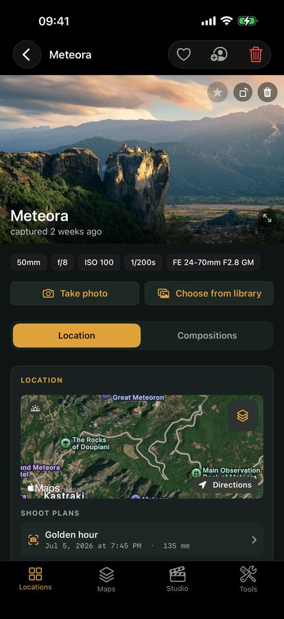
This is where a scouting tool does the cataloguing your RAW software can’t: Viewpoint files each spot by its real location the moment you capture it, and groups spots into Maps — a hierarchy of place that’s searchable from day one. It won’t keyword your RAW library for you (that stays your catalogue’s job), but it holds the location layer — the where — that the camera misses and that you’ll actually search by. Pair it with a location library and the organising is done before you’re home.
Folder structure that survives without software
One durable principle for the files themselves: build a folder structure that makes sense without any specific application, so your archive survives a change of software. A simple, dated, location-aware tree — Year / YYYY-MM-DD Location / files — is readable in any file browser, decades from now, with no catalogue database required. Keep the searchable location metadata in your catalogue and your scouting tool; keep the files in a plain, self-explaining structure. Then a future switch of editor never orphans your archive.
Where it hands off to your RAW catalogue
To be clear about the boundary: your RAW catalogue software still does the heavy lifting on the images — ratings, develop settings, subject keywords, the full library. What the location-first approach adds is the layer that software is worst at and that matters most to landscape work: a reliable, hierarchical, searchable record of place, captured in the field. Do the location layer at capture and the subject/quality keywording in your catalogue, and you can actually find any shot years later — by where you stood.
Quick-start checklist
- Location is the keyword you’ll search by — “where was that spot,” not “show me my f/11 shots.”
- Cameras record place worst — capture the meaningful location yourself.
- Use a hierarchy — continent → region → spot; it filters and browses.
- Keyword in the field — when you know the place, not from a thumbnail months later.
- Keep files in a plain, dated, location-named tree — readable without any software.
- Let your catalogue do subject/quality; let a scouting tool hold the location layer.