🗂️ Workflow & Library
How to build a photography location library you'll actually use
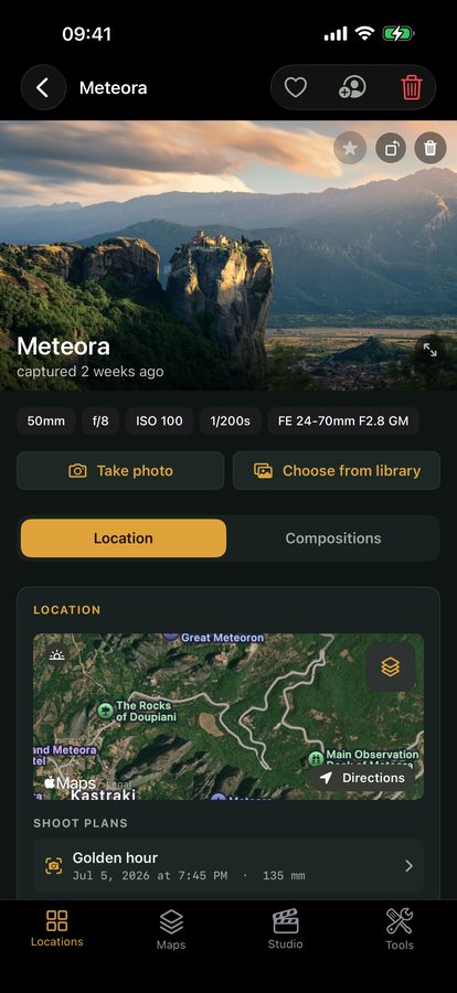
Every landscape photographer accumulates locations — a pull-off with a view, a bend in a river, a hillside that would be magic in the right light. And nearly everyone loses them: scribbled in notes apps, buried in a phone's camera roll, or just half-remembered as 'that place near the lake.' A location library is the system that stops the leak — a searchable, reusable record of where to shoot, what the light does there, and when to go back. Here's how to build one that still works when it holds five hundred spots, not five.
Most photographers’ “location system” is really a pile of good intentions: a few dropped pins, some camera-roll screenshots, a note that just says “waterfall — go back in autumn.” It works for a handful of spots and collapses under real use. The photographers who consistently shoot in great light aren’t luckier — they’ve built a location library: a deliberate, reusable record of where they shoot, so a place found once becomes a place they can return to at exactly the right moment. Here’s how to build one that survives scale.
Why most location systems die at spot number fifty
A spreadsheet or a folder of pins is fine at ten locations. At fifty it starts to fail, and the reasons are always the same:
- No structure. A flat list you can’t filter (“show me the coastal spots that work at sunrise”) becomes a wall of names you scroll past.
- Missing context. A pin with no notes tells you where but not what — which direction it faces, when the light hits, whether you need low tide.
- Split across apps. GPS in one place, notes in another, photos in a third; nothing joined up, so you never actually consult it.
- No trigger to return. Even a well-recorded spot is useless if nothing reminds you that this weekend is when its light lines up.
A real library fixes all four: it’s structured, it carries context, it keeps everything about a spot together, and it connects to a calendar of light.
Capture the spot the moment you find it
The single habit that makes a library valuable is recording a location on the spot, in the field — not from memory that evening. Standing there, you have everything; a day later you’ve lost half of it. Capture, at minimum:
- Exact GPS, dropped where you’d actually stand — not the car park.
- The direction you’re facing — the compass bearing decides whether this is a sunrise or a sunset spot.
- What the light and scene need — “sun clears the ridge ~07:50”, “best at low tide”, “foreground rock only exposed after rain”.
- A reference frame — even a quick phone snap of the composition is worth pages of notes.
Do this in one place that stamps the objective data for you — GPS, the date, the sun’s position, the weather — so your only job is the judgement that a machine can’t record.
Structure it so you can find things in three years
A library is only as good as your ability to retrieve from it. Group spots along the axis you actually search by. Three that work well, and combine:
- By region — everything within an hour of home, or grouped by a trip destination. The default, and how you’ll browse before heading out.
- By subject — waterfalls, coastal, woodland, astro-friendly dark sites. Lets you answer “where can I shoot moving water this weekend?”
- By condition — spots that sing in fog, in storm light, at low tide, under a new moon. The most powerful axis, because it maps a forecast onto your locations.
In Viewpoint these groupings are Maps — named collections a spot can belong to. Build a “North coast — sunrise” Map, an “Autumn woodland” Map, a “Dark-sky sites” Map, and browsing becomes a decision, not a scroll.
Turn the library into a reason to go out
A location library that just stores is a filing cabinet. The point is to make it act — to tell you when a saved spot is about to deliver. That’s the difference between a database and a scouting companion: for every spot you’ve saved, the almanac already knows when the sun and moon line up, and the weather tells you when the conditions you noted (“best in fog”) are setting up. Your library stops being a place you check and becomes a system that prompts you: this Saturday, this spot, this light.
Importing years of scattered locations
If you already have a decade of spots spread across pins and notes, don’t try to migrate everything at once — that’s the trap that stalls the whole project. Instead, seed the library with your best twenty, the places you actually return to, fully recorded. Then add each new find properly, in the field, going forward. Within a season the library holds your live shooting life; the old backlog you fold in a few at a time on quiet evenings. A growing library you use beats a perfect one you never finish.
Why this compounds
A location library is the rare photography asset that gets more valuable the longer you keep it. Every visit adds a note — the ridge blocks the sun later than you thought, the tide table was off by twenty minutes, the best tree lost a branch. After a few years you hold something no app or map can sell you: a personal, tested, condition-aware map of where your photographs come from. It’s the quiet foundation under every well-timed shot.
Quick-start checklist
- Record on the spot, not from memory — GPS where you’d stand, the bearing, the light notes.
- Let the objective data auto-stamp — date, sun position, weather — so you only add judgement.
- Group by region, subject and condition — the three axes you actually search by (Maps).
- Connect it to a calendar of light — so a saved spot prompts you when its conditions line up.
- Seed with your best twenty, then add every new find properly — don’t stall on migrating everything.
- Add a note every visit — the library deepens with use into something no map can sell you.